 © Mario Vidor
 © Mario Vidor
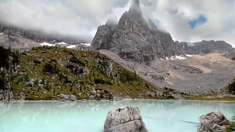
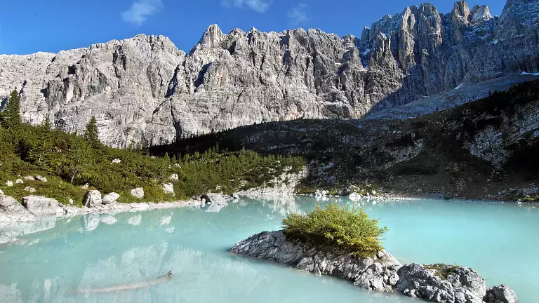
Lake Sorapìs lies within the vast natural amphitheatre of the Sorapìs massif, an impressive horseshoe-shaped cirque that opens toward Misurina. At its base stretch three small glaciers. The lake is located about 150 metres from Rifugio Vandelli and is dominated by the striking rock pinnacle known as the Dito di Dio (“Finger of God”).
From Passo Tre Croci via Trail 215
1h45 – Trail marker 215 – Difficulty: E (Hikers)
From the top of Passo Tre Croci, near the hotel, descend slightly toward Misurina along the main road and turn right onto a pleasant track. A large information board marks the start of the route, which undulates through the forest before reaching Rifugio Vandelli and Lake Sorapìs.
Along the way you will encounter:
- a scree section
- a rocky spur equipped with a metal ladder
- a short exposed stretch with a fixed rope (often slippery when wet)
- additional artificial steps that facilitate the ascent
From Passo Tre Croci via Forcella Malcuóira
3h – Trail markers 213–216–215 – Difficulty: EE (Expert hikers)
A longer but more varied and panoramic route to reach Lake Sorapìs.
From Cortina, drive toward Auronzo–Misurina and reach Passo Tre Croci (1,809 m). Skirt the hotel on the right and, near the small chapel, take the dirt road marked as trail 213.
The ascent through the forest includes some steep sections. Along the way you’ll find small fountains with humorous inscriptions such as “sparkling water”. Higher up, the forest gives way to open meadows, with views of the Cristallo massif behind you.
You then reach the Tardeiba plateau (2,129 m), where a junction indicates trail 216 to the left.
A grassy stretch leads to a moderate ascent across a scree slope. This scree leads to the base of a steep and demanding gully, which climbs up to Forcella Malcuóira (2,307 m). From here, the panorama is spectacular: to the right lie the grassy slopes of Cima de Malcuóira, crowned by its summit cross.
A sign at the pass indicates trail 216 toward Lake Sorapìs and Rifugio Vandelli. Beyond the pass, the trail descends into the Ciadin del Laudo basin—also known as the “chamois valley”. The view opens toward the Tre Cime di Lavaredo, the Cadini di Misurina, Lake Misurina, and the Val d’Ansiei.
A narrow exposed ledge equipped with a cable allows you to bypass a rocky spur. After this, the descent continues along the eastern flank of the Cime del Laudo into the Sorapìs valley. Surrounded by dwarf pines, you’ll eventually glimpse the lake in the distance.
At the bottom of the descent, the trail meets path 215. Turn right toward Rifugio Vandelli. Shortly after, a junction indicates left for the hut and right for Lake Sorapìs.
Loop from Passo Tre Croci via Forcella Malcuóira and return on Trail 215
4h45 – Trail markers 213–216–215 – Difficulty: EE
A complete loop is possible by ascending via the Forcella Malcuóira route and returning along the easier trail 215.
Useful Information
- Maps: Tabacco 1:25,000 – Sheet 03 “Cortina d’Ampezzo e Dolomiti Ampezzane”
- Water: Available at several points along the route
- Advice: Check the weather forecast and wear appropriate high‑mountain clothing