 © Shutterstock
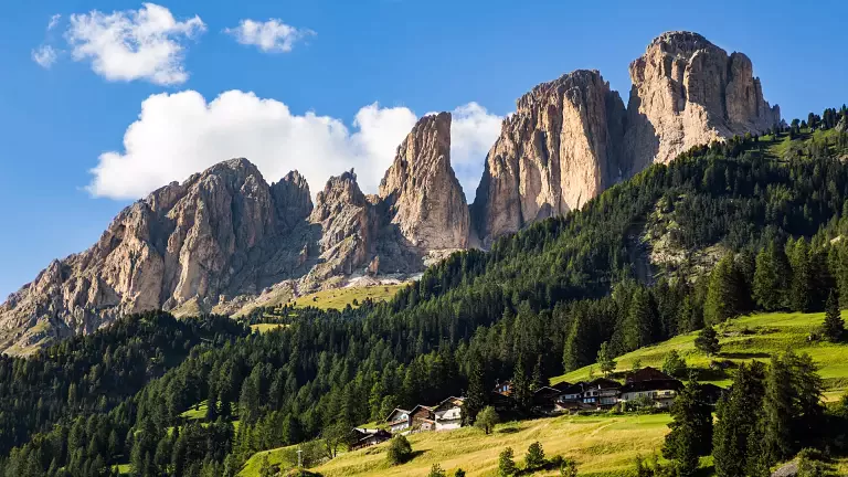
Col Rodella, easily reached from Campitello di Fassa by cable car or along well‑marked hiking trails, is one of the most spectacular panoramic balconies in the Dolomites. From here, your gaze sweeps across the Sassolungo, the Sella Towers, Sass Pordoi, the Marmolada, Gran Vernel, Colac, and Crepa Neigra—a breathtaking view that alone makes the outing worthwhile.
This itinerary is a great classic of the Val di Fassa, suitable for trained hikers, with an initial section perfect also for families.
Route description
From Col Rodella to Rifugio Friedrich August
From the upper station of the cable car, follow trail 557 – Friedrich August Weg, one of the most scenic routes in the area. Dedicated to the King of Saxony, the trail winds beneath the Sassolungo through pastures, rocky stretches, and wide‑open views. In a short time you reach Rifugio Friedrich August, ideal for a first break.
Towards Rifugio Sandro Pertini
Continue along the well‑marked path, suitable even for families, until you reach Rifugio Sandro Pertini. The panorama remains wide and continuous, with beautiful views of the Sella Group.
From Rifugio Pertini to Rifugio Sasso Piatto
Following the signs, continue towards Rifugio Sasso Piatto, which can be reached in about 2 hours – 2h15 total from the start. Here the landscape changes: the Sassolungo gives way to the broad open slopes leading towards the Val Duron.
Rifugio Sasso Piatto → Passo Duron (trail 594/4)
From the hut, take trail 594/4, which in about 1 hour (3h15 total) leads to Passo Duron, a natural border between Val di Fassa and the Alpe di Siusi. Those wishing to extend the hike can continue for another hour to Rifugio Alpe di Tires, one of the most iconic huts in the Dolomites.
Descent to Campitello di Fassa
From Passo Duron, descend along the wide track into the valley, then follow trail 532 to Rifugio Micheluzzi (1h30 – 4h45 total). From here, a pleasant descent through the valley floor brings you back to Campitello di Fassa in about 45 minutes (5h30 total).
Technical data
- Starting point: Col Rodella (Campitello di Fassa)
- Ending point: Campitello di Fassa
- Main viewpoint: Col Rodella
- Trails: 557, 594/4, 532
- Total duration: approx. 5h30
- Difficulty: medium – for trained hikers