 © Shutterstock
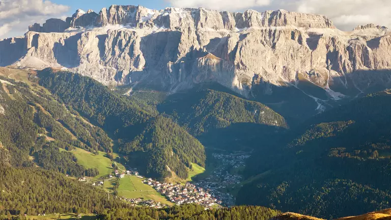
This Alpine Path of the Dolomites no. 2 unwinds along ridges, between the Isarco and Piave Rivers. It goes from the northern tips of the Dolomites to the Pre-Alps that overlook the Venetian plain and it connects two wonderful alpine towns: Bressanone and Feltre. This route goes through three provinces - Bolzano, Trento and Belluno - and eight chains of the Dolomites. This long route, which takes about two weeks, can be undertaken by experts who are well trained and have a good sense of direction and a minimum knowledge of mountaineering technique.
The "via delle leggende" ("legend route") starts from the vicinity of the Plose Group - Dolomites of Bressanone - and crosses Poma, Gardena, Pordoi, S. Pellegrino and Cereda Passes. Here begins the last part of this route: the great traverse of the Dolomites of Feltre.
Notes: this route is suggested to trained excursionists, who do not suffer from vertigo and have a good sense of direction. A minimum knowledge of mountaineering is reqired in order to afford some difficult stretches.
Technical data
Start Location: Brixen (BZ)
End Location: Feltre
Crossing time: 13 days
Trail Length: about 180 km
Shelters on the main route: 14
Bivouacs on the main route: 2
Restoration areas on the road: 15
Longest leg: from Feltre Bivouac to Dal Piaz hut – 11th leg, crossing time - 9 hours
Shortest leg: from Treviso hut to Cereda Pass – 9th leg, crossing time – 4 hours and 30 minutes
Total crossing time: almost 80 hours
Difficulty: from easy to challenging
Total altitude difference uphill: about 11,300 m
Total altitude difference downhill: about 11,200 m
Maximum altitude difference uphill: 1150 m, from San Pellegrino Pass to Mulaz – 7th leg
Maximum altitude difference downhill: 1550 m, from Rosetta hut to Treviso hut – 8th leg
Maximum trail altitude: Farangole pass, 2932 m
Minimum trail altitude: Feltre, 324 m
Dolomite groups along the way: 8 (Plose, Putia, Odle, Puez, Sella, Marmolada, Pale di San Martino, Vette Feltrine)
Opening period of shelters: from June to September
Recommended period: from the end of June to the end of September
Signs: adequate everywhere
Recommended topographic maps
Map Tabacco 1:25.000
- n.030 “Bressanone/Brixen-Val di Funes/Vilnöss”, from Brixen to Puez mountain hut
- n.07 “Alta Badia-Arabba-Marmolada”, from Rodella Pass to Malga Ciapela
- n.015 “Marmolda-Pelmo-Civetta-Moiazza”, from Pordoi Pass to San Pellegrino Pass
- n.06 “Val di Fassa e Dolomiti Fassane”, from Malga Ciapèla to Valles Pass
- n.022 “Pale di San Martino”, from Valles Pass to Bruno Boz hut and Le Vette
- n.023 “Alpi Feltrine-Le Vette-Cimónega”, from Bruno Boz hut to Feltre
Stages
Stage 1: Brixen - Città di Bressanone hut
Total altitude difference: 1900 m uphill from Bressanone, 435 m from Valcroce, 150 m from the ski lift
Lenght of the trail: about 27 km
Hiking time: 6 hours and 30 minutes; 1 hour and 30 minutes from Valcroce
Signs: no. 4-5 and 17 from Brixen; no. 7 from Valcroce
Difficulty: Hiking
Stage 2: Città di Bressanone hut - Genova hut
Total altitude difference: 500 m (uphill), 650 m (downhill)
Lenght of the trail: about 15 km
Hiking time: 5 hours
Signs: no.4
Difficulty: Hiking with easy and short equipped stretch
- Alternative Route 1: from Kreuz valley to the Schlüter hut
Stage 3: Genova hut - Puez hut
Total altitude difference: 850 m (uphill), 670 m (downhill)
Lenght of the trail: about 15 km
Hiking time: 6 hours
Signs: no. 3 and 2
Difficulty: Trekking with short equipped stretch
- Alternative Route 2: from the Schlüter hut to Puez hut through the Geisler way
- Alternative Route 3: from Fùrcia dla Róa on secured walking and climbing trails
Stage 4: Puez hut - Franco Cavazza al Pisciadù hut
Total altitude difference: 570 m (uphill), 460 m (downhill)
Lenght of the trail: about 10 km
Hiking time: 5 hours
Signs: no. 2 and 666
Difficulty: Trekking with short equipped stretch
- Alternative Route 4: from Grödner Pass to Pisciadù hut through the Tridentina-Klettersteig (fixed rope route)
Stage 5: Pisciadù hut - Castiglioni alla Marmolada hut
Total altitude difference: 750 m (uphill), 1280 m (downhill)
Lenght of the trail: about 19 km
Hiking time: 6-7 hours
Signs: no. 666, 647, 627, 601
Difficulty: Trekking with short equipped stretch
- Alternative Route 5: from the Castiglioni hut to the San Pellegrino Pass through the Marmoladascharte (col) (and via the peak of Marmolada)
Stage 6: Castiglioni alla Marmolada hut - San Pellegrino Pass
Total altitude difference: 1100 m (uphill), 1200 m (downhill)
Lenght of the trail: about 9 + 16 km
Hiking time: 2 + 5 hours
Signs: no. 610, 689, 694, 670, 607 and paved road
Difficulty: Touristic and Hiking
Stage 7: San Pellegrino Pass - Volpi al Mulaz hut
Total altitude difference: 1100 m (uphill), 500 m (downhill)
Lenght of the trail: about 14 km
Hiking time: 7 hours
Signs: no. 658 and 751
Difficulty: Trekking with short equipped stretch
Stage 8: Volpi al Mulaz hut - Pedrotti alla Rosetta hut
Total altitude difference: 760 m (uphill), 750 m (downhill)
Lenght of the trail: about 8 km
Hiking time: 5 hours
Signs: no. 703
Difficulty: Trekking, climbing on the Sentiero delle Farangole path
- Alternative Route 6: from Mulàz hut to Rosetta hut through the Rolle Pass, the Sentiero del Cacciatore (path) and Col Verde
Stage 9: Rosetta hut - Pradidali hut - Treviso hut
Total altitude difference: 720 m (uphill), 1600 m (downhill)
Lenght of the trail: about 14 km
Hiking time: 7 hours
Signs: no. 702, 715, 709, 711, 707
Difficulty: Trekking and climbing
- Alternative Route 7: from the Rosetta hut to the Treviso hut through the Malga Canali
Stage 10: Treviso hut - Cereda Pass
Total altitude difference: 1150 m (uphill), 900 m (downhill)
Lenght of the trail: about 10 km
Hiking time: 4 hours and 30 minutes
Signs: no. 718
Difficulty: Trekking
- Variant VIII: from Rifugio Treviso to Passo del Comedon and Rifugio Boz via Rifugio Malga Cavallera
Elevation gain: 780 m ascent, 1,100 m descent
Distance: approx. 13.3 km
Hiking time: approx. 5 hours
From Rifugio Treviso, follow trail 718 to Forcella d’Oltro, then descend on the southern side. At the junction just below the saddle, turn left (east) and reach Rifugio Malga Cavallera in about 40 minutes.
Alternatively, from Rifugio Treviso follow trail 720 to Forcella delle Mughe: from the saddle, reach Bivacco Menegazzi in about 45 minutes, then continue for another 5 minutes to Rifugio Malga Cavallera. To rejoin the classic Alta Via route, descend from Rifugio Malga Cavallera towards Domadore and then Padreterno, where the route joins trail 801 leading up to Passo del Comedon. Hiking time to the junction with trail 801 is approximately 2 hours and 15 minutes. From the southern side, descending from Passo del Comedon along trail 801, at Malga Fratton follow the forest road for about 15 minutes to a junction, then turn right towards Padreterno. Cross the road and take the forest track towards Domadore – Rifugio Malga Cavallera, which can be reached in approximately 2 hours and 30 minutes.
Stage 11: Cereda Pass - Feltre Walter Bodo Bivouac - Bruno Boz hut
Total altitude difference: 1200 m (uphill), 600 m (downhill)
Lenght of the trail: about 14 km
Hiking time: 6 hours and 30 minutes
Signs: no. 801
Difficulty: Trekking and climbing along the Intaiada and Troi dei Caserìn paths
Stage 12: Boz hut - Dal Piaz hut
Total altitude difference: 900 m (uphill), 650 m (downhill)
Lenght of the trail: about 15 km
Hiking time: 7 hours
Signs: no. 801
Difficulty: Trekking and climbing
Stage 13: Dal Piaz hut - Croce d’Aune - Feltre
Total altitude difference: 980 m downhill to Croce d'Aune, 1670 m to Feltre
Lenght of the trail: about 19 km
Hiking time: 6 hours up to Feltre
Signs: no. 801 and paved road
Difficulty: Touristic and Hiking
N.B. Before starting the itinerary, it is advisable to find out about the weather and verify the opening of the shelters and their availability.