 © Depositphotos
Rising alongside the nearby Gran Furchetta, Sass Rigais is the highest summit of the Odle/Geisler Group and one of the most iconic peaks in the Dolomites. Its panoramic ridge offers sweeping views over the pristine Val di Funes, making it a favourite destination for hikers and via ferrata enthusiasts.
Access
From Bolzano, follow the Isarco Valley towards Chiusa. Before reaching the town, turn into Val Gardena and continue past Ortisei to the village of Santa Cristina. Here you can park and either take the Col Raiser cable car or walk up to the Firenze Hut along the forest road.
Itinerary Overview
From Santa Cristina, choose whether to:
- take the Col Raiser cable car to 2107 m,
- or hike to the Firenze Hut (2037 m) along the wide gravel road.
Your approach will vary depending on whether you plan to climb the East or West via ferrata. This description follows the classic traverse from East to West, starting from Col Raiser.
Approach to the East Ferrata
From the Col Raiser station, take the path immediately to the right and descend about 70 m to the clearly visible Firenze Hut (approx. 20 minutes). From the hut, follow trail no. 13 towards Sass Rigais. The path climbs gently through open alpine meadows before reaching the broad plateau of Plan de Ciautier.
Continue to the right, staying beneath the imposing walls of Sass Rigais, and ascend diagonally into the Val Salieres. A well‑marked trail winds up the scree slope to the wide saddle between Gran Furchetta (right) and Sass Rigais (left). Time to the saddle: about 1 hour.
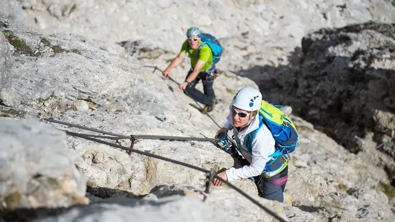
Start of the Via Ferrata (East Side)
From the saddle, turn left towards the rocky base of the mountain. A short section of easy grade I scrambling on unprotected rock leads to a ridge of mixed rock and scree. Here the via ferrata begins, equipped with steel cables and iron rungs on the steeper passages. Time to the start of the ferrata: 1 h 30 min from Col Raiser.
Descent via the West Route
From the summit, you can return along the ascent route or complete the full traverse by descending the north‑east slope. A steep, marked trail leads downwards (early‑season caution advised due to possible snow or ice). Near the notch between Sass Rigais and Furchetta, you’ll encounter the most technical section, equipped with cables and metal steps.
Once past this passage, the trail continues southwards down the scree of Val Salieres, eventually rejoining trail no. 13. From here, it’s an easy return to Plan de Ciautier, and then back to Col Raiser or the Firenze Hut.
Technical Details
- Route type: 60% steel cable, 30% exposed trail, 10% easy scrambling
- Total elevation gain: approx. 925 m
- Ascent time: 3:00–3:30 h
- Elevation gain to ferrata start: approx. 600 m (2:00–2:15 h)
- Ferrata elevation gain: approx. 325 m (1:00–1:15 h)
- Equipment: standard via ferrata kit, helmet, gloves
- Difficulty: moderate; exposed sections and short grade I climbing