 © Società Cooperativa Turistica Naturno
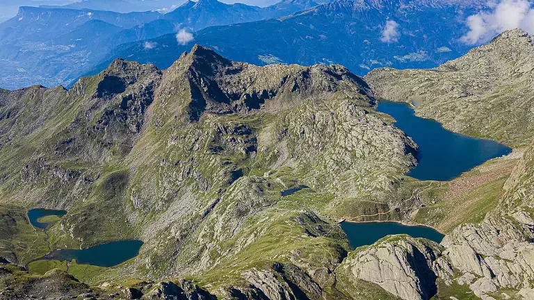
In the wild heart of the Gruppo di Tessa Nature Park, the ten Sopranes Lakes form the largest high‑altitude lake district in South Tyrol/Alto Adige. This circular route is a true adventure for experienced hikers: it demands stamina, surefootedness, and freedom from vertigo. In return, it offers breathtaking views, ever‑changing perspectives, and the magic of alpine waters shimmering among towering peaks.
The trail
The hike begins at the valley station of the Alta Muta cable car, which quickly carries you up to higher ground. From there, a steep fifteen‑minute climb leads to the Steinegg inn and the Leiteralm mountain hut. Continuing on, you take the Merano High Mountain Trail to the left—a spectacular section suitable only for those without vertigo—which leads to the Hochganghaus refuge (1,839 m).
The ascent continues up to the Hochgangscharte pass (2,455 m), where a steady step and freedom from vertigo are essential. Beyond the pass, the path bends left and skirts the enchanting Langsee (Long Lake) before descending gently to the Oberkaser hut (2,131 m), an ideal spot for a rest. From here, the Jägersteig trail (no. 22) takes you to the Mutkopf restaurant (1,684 m). Finally, the route leads back to the Alta Muta cable car, from where you return comfortably to Tirolo, completing the circular hike.
How to get there
- By car: take the Bolzano–Merano expressway, exit at Merano Sud/Sinigo, and continue towards Tirolo. Passing along Via Principale and Via Aslago, you reach the valley station of the Muta cable car.
- Parking: available at the valley station. Free for one day if using the cable car; covered parking available for a fee.
Public transport
- Line 221: Merano – Tirolo bus station
- Line 222: Monte Benedetto – Tirolo bus station – Tirolo Croce