© Alessia Dell'Andrea | Marmolada Rocca Pietore Dolomites Tourism Association
 © Consorzio Turistico Marmolada Rocca Pietore Dolomiti
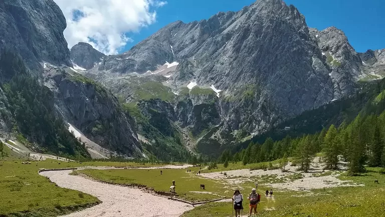
A fascinating itinerary through Val Ombretta, one of the most beautiful valleys of the Marmolada Group, offering stunning views of the southwest face of the Marmolada. Numerous remains from the First World War can be found along the route.
From Malga Ciapela, continue past the “Malga Ciapela” campsite and, after about one kilometre, reach a bridge closed by a barrier. Leave your car here and continue on foot. After crossing the bridge, take the wide mule track that climbs to the left; it is initially quite steep, then becomes gentler and more regular.
Ignore the very steep shortcut branching off to the right and continue along the comfortable road, which rises gradually in wide switchbacks at the foot of Monte Fop (2,550 m).
At a junction where trail no. 689 branches left toward Val di Franzedas, keep right and follow the wide mule track, which soon leads to the entrance of Val Ombretta. Here the valley opens magnificently, with the impressive south face of the Marmolada on the right and the Pale of Monte Fop on the left, and is closed at the end by Monte Ombrettola (2,931 m), Sass Vernale (3,058 m) and the Cime di Ombretta Orientale (3,011 m). Standing out among them is the peculiar shape of the Fungo d’Ombretta (2,653 m), towering above Rifugio Falier.
Here the mule track ends and the route continues on a well-marked path passing through the huts of Malga Ombretta (1,904 m). From here, turn right following the signs to reach the Geographical Centre of the Dolomites, marked by a totem enclosing a stone heart, symbolising that Val Ombretta is the central point of the Dolomites UNESCO area. In about 40 minutes you reach Rifugio Onorio Falier.
Just below the hut, you can visit interesting wartime tunnels carved into the rock.
For those wishing to continue, two options are available:
- trail no. 610 leading to Passo Ombretta,
- or trail no. 612, starting behind the hut and climbing the Vallon d’Ombrettola.